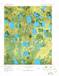
1970 Map of Beechey Point A-3 NW
USGS Topo · Published 1971About this map
Put River State No 1 stands as a focal point of industrial activity on this orthophotomap of the Alaska North Slope, reflecting the early exploration and infrastructure development of the Prudhoe Bay region. The landscape is dominated by a complex network of thaw lakes and the meandering course of the Putuligayuk River, which cuts across the tundra. This map captures a pivotal moment when seasonal transportation routes were essential for navigating the Arctic terrain, evidenced by the long Winter Trail stretching across the permafrost. The use of aerial photography from June 1970 provides a detailed visual record of the surface hydrology and the emerging footprint of energy extraction before the full-scale expansion of permanent roads and facilities.
Find a feature on this map
5 named features on this map. Tap any name to fly to it.
Don’t see what you’re looking for? This feature index may not catch every label — zoom into the map to look around manually.
Map Details
Editions of this 1970 Beechey Point A-3 NW Map
2 editions found
Other maps of this area

1951 · Beechey Point
USGS Topo · 1:250,000

1955 · Beechey Point
USGS Topo · 1:250,000

1955 · Beechey Point B-4
USGS Topo · 1:63,360

1955 · Beechey Point A-3
USGS Topo · 1:63,360

1955 · Beechey Point A-4
USGS Topo · 1:63,360

1955 · Beechey Point B-3
USGS Topo · 1:63,360

1960 · Beechey Point
USGS Topo · 1:250,000

1962 · Beechey Point B-4
USGS Topo · 1:50,000

1964 · Beechey Point
USGS Topo · 1:250,000
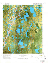
1970 · Beechey Point A-4 NE
USGS Topo · 1:24,000