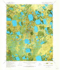
1970 Map of Beechey Point A-3 NW
USGS Topo · Published 1973About this map
Putuligayuk River meanders across this Arctic coastal landscape, captured during a 1970 aerial survey of the North Slope. This orthophotomap provides a unique visual record of the thaw-lake plains, where the vast network of water bodies and saturated tundra defines the geography. Early industrial activity in the region is marked by Put River State No 1, reflecting the initial stages of resource exploration on state lands. Navigation across this permafrost environment is primarily facilitated by a Winter Trail, a vital transport route that relies on frozen ground for access. The map reveals a landscape largely untouched by permanent infrastructure, dominated by the natural drainage patterns and the seasonal pathways required for movement in the high Arctic.
Find a feature on this map
5 named features on this map. Tap any name to fly to it.
Don’t see what you’re looking for? This feature index may not catch every label — zoom into the map to look around manually.
Map Details
Editions of this 1970 Beechey Point A-3 NW Map
2 editions found
Other maps of this area

1951 · Beechey Point
USGS Topo · 1:250,000

1955 · Beechey Point
USGS Topo · 1:250,000

1955 · Beechey Point B-4
USGS Topo · 1:63,360

1955 · Beechey Point A-3
USGS Topo · 1:63,360

1955 · Beechey Point A-4
USGS Topo · 1:63,360

1955 · Beechey Point B-3
USGS Topo · 1:63,360

1960 · Beechey Point
USGS Topo · 1:250,000

1962 · Beechey Point B-4
USGS Topo · 1:50,000

1964 · Beechey Point
USGS Topo · 1:250,000
1970 · Beechey Point A-4 NE
USGS Topo · 1:24,000