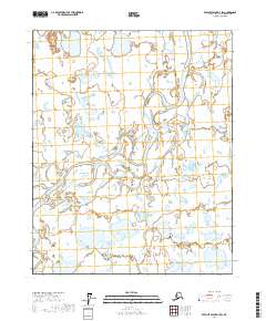
2017 Map of Beechey Point A-4 SW
USGS Topo · Published 2017About this map
The Kuparuk River meanders across this Arctic landscape, its shifting channels and braided waters dominating the central and eastern portions of the terrain. This environment is characterized by a dense network of wetlands and thaw lakes typical of the North Slope, where water bodies are constantly reshaped by seasonal freeze-thaw cycles. The survey provides a precise look at the land division within the Public Land Survey System, specifically detailing the corners and boundaries of T9n R11e, T9n R12e, T8n R11e, and T8n R12e. These township and range designations reflect the systematic grid overlaying the coastal plain, used to manage resource extraction and environmental conservation efforts in the region. The absence of roads or permanent structures emphasizes the specialized, industrial, or scientific nature of activity in this part of Alaska during the early 21st century.
Find a feature on this map
5 named features on this map. Tap any name to fly to it.
Don’t see what you’re looking for? This feature index may not catch every label — zoom into the map to look around manually.
Map Details
Editions of this 2017 Beechey Point A-4 SW Map
This is the sole edition of this map. No revisions or reprints were ever made.
Other maps of this area

1951 · Beechey Point
USGS Topo · 1:250,000

1951 · Sagavanirktok D-5
USGS Topo · 1:250,000

1955 · Beechey Point
USGS Topo · 1:250,000

1955 · Beechey Point A-5
USGS Topo · 1:63,360

1955 · Beechey Point A-4
USGS Topo · 1:63,360
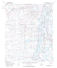
1955 · Sagavanirktok D-5
USGS Topo · 1:63,360

1955 · Sagavanirktok D-4
USGS Topo · 1:63,360

1956 · Sagavanirktok
USGS Topo · 1:250,000

1958 · Sagavanirktok
USGS Topo · 1:250,000

1960 · Beechey Point
USGS Topo · 1:250,000