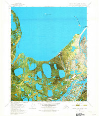
1970 Map of Beechey Point B-3 SE
USGS Topo · Published 1973About this map
Prudhoe Bay dominates this orthophotomap, showing the Arctic coastline during a transformative period for the North Slope. Captured via aerial photography in 1970, the map reveals the intricate network of thaw lakes and braided river channels that define this tundra landscape. The eastern edge is shaped by the wide, multi-channeled Sagavanirktok River, while the smaller Putuligayuk River winds through the wetlands to the west. Near the shore, Gull Island and the Niakuk Islands provide context for the coastal environment. This 1970 snapshot serves as a critical spatial baseline for the region, documenting the land and water patterns of the Alaskan arctic at the dawn of a major industrial era.
Find a feature on this map
7 named features on this map. Tap any name to fly to it.
Don’t see what you’re looking for? This feature index may not catch every label — zoom into the map to look around manually.
Map Details
Editions of this 1970 Beechey Point B-3 SE Map
2 editions found

Other maps of this area

1951 · Beechey Point
USGS Topo · 1:250,000

1955 · Beechey Point
USGS Topo · 1:250,000

1955 · Beechey Point B-2
USGS Topo · 1:63,360

1955 · Beechey Point A-2
USGS Topo · 1:63,360

1955 · Beechey Point A-3
USGS Topo · 1:63,360

1955 · Beechey Point B-3
USGS Topo · 1:63,360

1960 · Beechey Point
USGS Topo · 1:250,000

1962 · Beechey Point B-2
USGS Topo · 1:50,000
1962 · Beechey Point A-2
USGS Topo · 1:50,000

1964 · Beechey Point
USGS Topo · 1:250,000