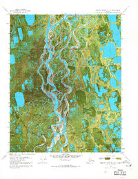
1970 Map of Beechey Point B-4 SE
USGS Topo · Published 1971About this map
Industrial outposts and early oil exploration infrastructure dot the North Slope landscape in this 1970 orthophotomap. The intricate network of the Put River and its surrounding wetlands dominates the terrain, captured during a summer aerial survey that reveals the complex drainage patterns of the Alaskan tundra. Early petroleum activity is evidenced by several drilling locations, including So Eileen State No 1, Hurl State No 1, and Placid Et Al State No 1, which reflect the initial phase of development in the Beechey Point region. Aviation access was critical for these remote operations, provided by facilities such as the North Kuparuk State No 1 Landing Strip and the Hull Landing Strip. Seasonal transport routes like the Winter Trail connected these isolated points, while Rivers Camp Service City served as a focal point for personnel and logistics in the burgeoning oil field.
Find a feature on this map
15 named features on this map. Tap any name to fly to it.
Don’t see what you’re looking for? This feature index may not catch every label — zoom into the map to look around manually.
Map Details
Editions of this 1970 Beechey Point B-4 SE Map
2 editions found
Other maps of this area

1951 · Beechey Point
USGS Topo · 1:250,000

1955 · Beechey Point
USGS Topo · 1:250,000

1955 · Beechey Point B-4
USGS Topo · 1:63,360

1955 · Beechey Point A-3
USGS Topo · 1:63,360

1955 · Beechey Point A-4
USGS Topo · 1:63,360

1955 · Beechey Point B-3
USGS Topo · 1:63,360

1960 · Beechey Point
USGS Topo · 1:250,000

1962 · Beechey Point B-4
USGS Topo · 1:50,000

1964 · Beechey Point
USGS Topo · 1:250,000
1970 · Beechey Point A-4 NE
USGS Topo · 1:24,000