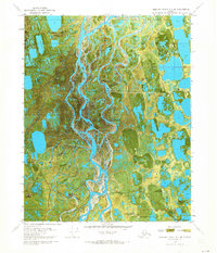
1970 Map of Beechey Point B-4 SE
USGS Topo · Published 1974About this map
Put River winds through this coastal landscape, which was being rapidly shaped by industrial activity at the start of the 1970s. This orthophotomap, derived from 1970 aerial photography, documents the infrastructure of the North Slope oil fields during an era of initial development. Named industrial sites like S E Eileen State No 1 and Hurl State No 1 are visible across the terrain, connected by the seasonal Winter Trail. The reliance on aviation in this remote environment is evident through the placement of the North Kuparuk State Landing Strip and the Hull Landing Strip. Localized support hubs such as Rivers Camp Service City and specific industrial clearings like Western Pad provide a detailed look at the early footprint of resource extraction on the Alaskan tundra.
Find a feature on this map
15 named features on this map. Tap any name to fly to it.
Don’t see what you’re looking for? This feature index may not catch every label — zoom into the map to look around manually.
Map Details
Editions of this 1970 Beechey Point B-4 SE Map
2 editions found
Other maps of this area

1951 · Beechey Point
USGS Topo · 1:250,000

1955 · Beechey Point
USGS Topo · 1:250,000

1955 · Beechey Point B-4
USGS Topo · 1:63,360

1955 · Beechey Point A-3
USGS Topo · 1:63,360

1955 · Beechey Point A-4
USGS Topo · 1:63,360

1955 · Beechey Point B-3
USGS Topo · 1:63,360

1960 · Beechey Point
USGS Topo · 1:250,000

1962 · Beechey Point B-4
USGS Topo · 1:50,000

1964 · Beechey Point
USGS Topo · 1:250,000
1970 · Beechey Point A-4 NE
USGS Topo · 1:24,000