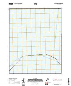
2018 Map of Beechey Point C-3 SE
USGS Topo · Published 2018About this map
The Atlantic Ocean dominates the upper half of this coastal Alaskan landscape, illustrating the vast maritime expanse off the North Slope. Surveyed for the T13n R15e township, the map defines the transition from sea to land along a remote stretch of the Arctic coast. The shoreline is marked by a distinctive boundary that suggests the low-lying, tidal nature of this northern frontier. Below the water, the terrain is partitioned into standard section blocks, including sections 5, 4, and 3, which provide a geographic framework for this sparsely documented wilderness. The coastal profile depicted here represents a specific moment in the ever-changing northern shoreline during the early 21st century.
Find a feature on this map
12 named features on this map. Tap any name to fly to it.
Don’t see what you’re looking for? This feature index may not catch every label — zoom into the map to look around manually.
Map Details
Editions of this 2018 Beechey Point C-3 SE Map
This is the sole edition of this map. No revisions or reprints were ever made.
Other maps of this area

1951 · Beechey Point
USGS Topo · 1:250,000

1955 · Beechey Point
USGS Topo · 1:250,000

1955 · Beechey Point B-2
USGS Topo · 1:63,360

1955 · Beechey Point B-3
USGS Topo · 1:63,360

1960 · Beechey Point
USGS Topo · 1:250,000

1962 · Beechey Point B-2
USGS Topo · 1:50,000

1964 · Beechey Point
USGS Topo · 1:250,000
1970 · Beechey Point B-3 NW
USGS Topo · 1:24,000
2017 · Beechey Point B-3 NW
USGS Topo · 1:25,000
2017 · Beechey Point B-3 NE
USGS Topo · 1:25,000