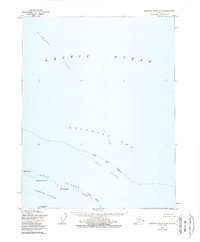
1955 Map of Beechey Point C-4
USGS Topo · Published 1988About this map
The North Slope Borough shoreline meets the high Arctic in this 1950s survey, detailing a landscape defined by shifting barrier islands and shallow coastal waters. The Jones Islands chain, including Pingok Island, Bertoncini Island, and Cottle Island, forms a protective arc between the open Beaufort Sea and the relatively sheltered Simpson Lagoon. This maritime environment is marked by significant underwater features such as Stamukhi Shoal and Cat Shoal, which indicate the complex bathymetry of the Arctic Ocean shelf. The survey provides a precise record of the coastline before major industrial development, capturing the placement of family-named landmarks like Bodfish Island and Bodis Island, alongside prominent coastal markers like Kavearak Point.
Find a feature on this map
14 named features on this map. Tap any name to fly to it.
Don’t see what you’re looking for? This feature index may not catch every label — zoom into the map to look around manually.
Map Details
Editions of this 1955 Beechey Point C-4 Map
2 editions found
Other maps of this area

1951 · Beechey Point
USGS Topo · 1:250,000

1955 · Beechey Point
USGS Topo · 1:250,000
1955 · Beechey Point C-4
USGS Topo · 1:63,360

1955 · Beechey Point B-4
USGS Topo · 1:63,360
1955 · Beechey Point C-5
USGS Topo · 1:63,360

1955 · Beechey Point B-5
USGS Topo · 1:63,360

1955 · Beechey Point B-3
USGS Topo · 1:63,360

1960 · Beechey Point
USGS Topo · 1:250,000

1962 · Beechey Point B-4
USGS Topo · 1:50,000
1962 · Beechey Point C-4
USGS Topo · 1:50,000