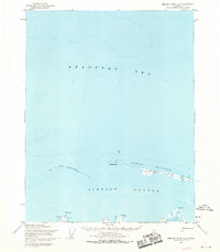
1955 Map of Beechey Point C-5
USGS Topo · Published 1969About this map
The Beaufort Sea coastline of Alaska's North Slope is captured here during the mid-1950s, revealing a landscape defined by barrier islands and shallow lagoons. The Jones Islands chain, including Pingok Island and Leavitt Island, forms a protective arc against the Arctic waters, creating the sheltered Simpson Lagoon. This region, mapped by the Army Map Service, shows early infrastructure on the mainland such as the Landing Strip at Oliktok Point and survey markers like West Base and East Base. Small scattered Cabins and a singular Cellar represent the sparse human footprint in this remote maritime environment, primarily used for subsistence or early surveying operations. The detailed hydrographic data, compiled from USC&GS charts, emphasizes the shifting nature of these low-lying islands and the critical importance of sheltered points like Milne Point for coastal navigation and resource exploration.
Find a feature on this map
16 named features on this map. Tap any name to fly to it.
Don’t see what you’re looking for? This feature index may not catch every label — zoom into the map to look around manually.
Map Details
Editions of this 1955 Beechey Point C-5 Map
2 editions found
Other maps of this area

1951 · Harrison Bay
USGS Topo · 1:250,000

1951 · Beechey Point
USGS Topo · 1:250,000

1955 · Harrison Bay
USGS Topo · 1:250,000

1955 · Beechey Point
USGS Topo · 1:250,000

1955 · Harrison Bay C-1
USGS Topo · 1:63,360
1955 · Beechey Point C-4
USGS Topo · 1:63,360

1955 · Beechey Point B-4
USGS Topo · 1:63,360

1955 · Harrison Bay B-1
USGS Topo · 1:63,360

1955 · Beechey Point B-5
USGS Topo · 1:63,360

1960 · Beechey Point
USGS Topo · 1:250,000