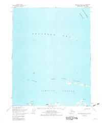
1955 Map of Beechey Point C-5
USGS Topo · Published 1982About this map
Simpson Lagoon dominates this 1955 survey of Alaska's northern coast, separated from the open Beaufort Sea by a string of barrier islands. The Jones Islands chain, including Pingok Island and Leavitt Island, protects the shallow inner waters and the mainland shoreline. This era of mapping captured the area just as Arctic exploration intensified, evidenced by the presence of a Landing Strip and specialized surveying markers like West Base and East Base near Oliktok Point. Human activity is sparse but notable, with scattered Cabins and a lone Cabin near Milne Point indicating seasonal habitation or early research outposts in this isolated landscape. Further offshore, the Stamukhi Shoal marks a significant underwater feature within the sea.
Find a feature on this map
14 named features on this map. Tap any name to fly to it.
Don’t see what you’re looking for? This feature index may not catch every label — zoom into the map to look around manually.
Map Details
Editions of this 1955 Beechey Point C-5 Map
2 editions found
Other maps of this area

1951 · Harrison Bay
USGS Topo · 1:250,000

1951 · Beechey Point
USGS Topo · 1:250,000

1955 · Harrison Bay
USGS Topo · 1:250,000

1955 · Beechey Point
USGS Topo · 1:250,000

1955 · Harrison Bay C-1
USGS Topo · 1:63,360
1955 · Beechey Point C-4
USGS Topo · 1:63,360

1955 · Beechey Point B-4
USGS Topo · 1:63,360

1955 · Harrison Bay B-1
USGS Topo · 1:63,360
1955 · Beechey Point C-5
USGS Topo · 1:63,360

1955 · Beechey Point B-5
USGS Topo · 1:63,360