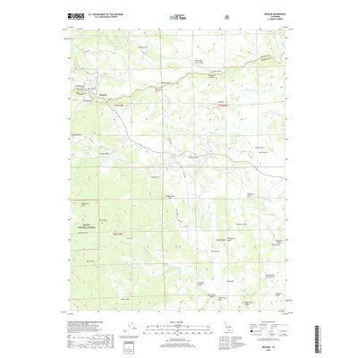
2018 Map of Beegum
USGS Topo · Published 2018About this map
Beegum sits at the junction of Beegum Rd and Platina Rd, marking a central point of settlement in this northern California landscape. The terrain is defined by a dense network of drainages such as Beegum Cr and the Middle Fork Cottonwood Cr, which carve through the boundary between Shasta and Tehama counties. To the south, the protected lands of the Trinity National Forest dominate the topography, featuring significant heights like Patty mocus Butte and Sugarloaf Mtn. This 2018 survey reveals a region of small-scale mountain roads, including Tedoc Rd and Olympia Dr, that provide access to remote areas like Wild Horse Ridge and Rubberboot Gap. The distribution of named gulches and canyons, from Whiteman Canyon to Goldsborough Gulch, suggests a long history of local geographic identification in this complex watershed.
Find a feature on this map
60 named features on this map. Tap any name to fly to it.
Don’t see what you’re looking for? This feature index may not catch every label — zoom into the map to look around manually.
Map Details
Editions of this 2018 Beegum Map
This is the sole edition of this map. No revisions or reprints were ever made.
Other maps of this area

1890 · Red Bluff
USGS Topo · 1:250,000

1894 · Red Bluff
USGS Topo · 1:250,000

1949 · Colyear Springs
USGS Topo · 1:62,500

1951 · Chanchelulla Peak
USGS Topo · 1:62,500

1952 · Ono
USGS Topo · 1:62,500

1954 · Yolla Bolly
USGS Topo · 1:62,500

1957 · Colyear Springs
USGS Topo · 1:62,500

1958 · Redding
USGS Topo · 1:250,000
1967 · Cold Fork
USGS Topo · 1:24,000
1979 · Red Bluff
USGS Topo · 1:100,000