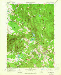
1964 Map of Belchertown
USGS Topo · Published 1966About this map
The hills and lowlands of eastern Hampshire County are defined by a complex network of brooks and ridges as they appeared in the mid-1960s. The settlement of Belchertown serves as a focal point, surrounded by significant institutional and conservation lands including the Belchertown State School and the Belchertown State Reservation. To the west, the Holyoke Range rises toward Long Mtn, while the eastern boundary is dominated by the Quabbin Reservoir and its protected Quabbin Reservation. The map details the local infrastructure of the era, from the winding tracks of the Central Vermont and Boston and Maine railroads to the St Hyacinths Seminary and College. Several small cemeteries such as Lake Vale Cem and Munsell Cem are located throughout the landscape, providing valuable locations for genealogical research and local history.
Find a feature on this map
69 named features on this map. Tap any name to fly to it.
Don’t see what you’re looking for? This feature index may not catch every label — zoom into the map to look around manually.
Map Details
Editions of this 1964 Belchertown Map
3 editions found
Other maps of this area

1885 · Northampton
USGS Topo · 1:62,500

1886 · Springfield
USGS Topo · 1:62,500

1886 · Northampton
USGS Topo · 1:62,500

1887 · Palmer
USGS Topo · 1:62,500

1887 · Belchertown
USGS Topo · 1:62,500

1889 · Springfield
USGS Topo · 1:62,500

1889 · Palmer
USGS Topo · 1:62,500

1890 · Belchertown
USGS Topo · 1:62,500

1891 · Northampton
USGS Topo · 1:62,500

1893 · Northampton
USGS Topo · 1:62,500