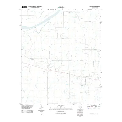
2010 Map of Belcherville
USGS Topo · Published 2010About this map
The Red River defines the northern boundary of this landscape, where the flatlands of North Texas meet the Oklahoma border. The small settlement of Belcherville sits centrally, anchored by a network of rural routes like the Old Wichita Hwy and FM 1816. For those tracing local heritage, the map identifies several significant burial grounds, including the Belcherville Cemetery, the Long Branch Cemetery to the southeast, and the Red River Station Cemetery perched near the riverbank. This area is heavily defined by its drainage systems, with numerous watercourses such as Barrel Springs Creek, Belknap Creek, and Salt Creek winding through the territory toward the river. To the east, Club Lake and its associated recreation roads provide a distinct contrast to the surrounding agricultural grid. The presence of Eureka School Rd suggests the historical location of rural educational hubs that once served these dispersed farming communities.
Find a feature on this map
36 named features on this map. Tap any name to fly to it.
Don’t see what you’re looking for? This feature index may not catch every label — zoom into the map to look around manually.
Map Details
Editions of this 2010 Belcherville Map
This is the sole edition of this map. No revisions or reprints were ever made.
Other maps of this area

1905 · Montague
USGS Topo · 1:125,000

1954 · Sherman
USGS Topo · 1:250,000

1958 · Sherman
USGS Topo · 1:250,000

1960 · Buzzard Roost Knob
USGS Topo · 1:24,000

1961 · Stoneburg
USGS Topo · 1:24,000

1961 · Montague
USGS Topo · 1:24,000
1968 · Terral
USGS Topo · 1:24,000

1968 · Nocona
USGS Topo · 1:24,000

1968 · Fleetwood
USGS Topo · 1:24,000
1968 · Prairie Valley School
USGS Topo · 1:24,000