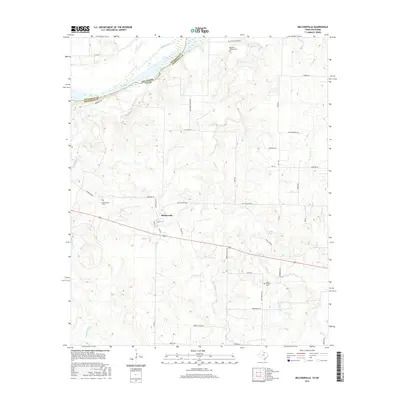
2016 Map of Belcherville
USGS Topo · Published 2016About this map
Belcherville lies at the heart of this North Texas survey, where the rolling prairies of Montague County descend toward the Red River. This 2016 record captures a landscape deeply connected to its frontier origins, notably via the Red River Station Rd, which traces a path toward the historic crossing point into Oklahoma. The map reveals a pattern of rural settlement defined by small cemeteries such as Red River Station Cem and Belcherville Cem, serving as critical touchstones for local genealogical research. Water management and drainage are central to the terrain, with Club Lake providing a focal point for the eastern drainage into Long Br, while Barrel Springs Cr and Belknap Cr carve through the southern uplands. Modern infrastructure like the Old Wichita Hwy parallels older routes, illustrating the evolution of transport in this borderland region.
Find a feature on this map
44 named features on this map. Tap any name to fly to it.
Don’t see what you’re looking for? This feature index may not catch every label — zoom into the map to look around manually.
Map Details
Editions of this 2016 Belcherville Map
This is the sole edition of this map. No revisions or reprints were ever made.
Other maps of this area

1905 · Montague
USGS Topo · 1:125,000

1954 · Sherman
USGS Topo · 1:250,000

1958 · Sherman
USGS Topo · 1:250,000

1960 · Buzzard Roost Knob
USGS Topo · 1:24,000

1961 · Stoneburg
USGS Topo · 1:24,000

1961 · Montague
USGS Topo · 1:24,000
1968 · Terral
USGS Topo · 1:24,000

1968 · Nocona
USGS Topo · 1:24,000

1968 · Fleetwood
USGS Topo · 1:24,000
1968 · Prairie Valley School
USGS Topo · 1:24,000