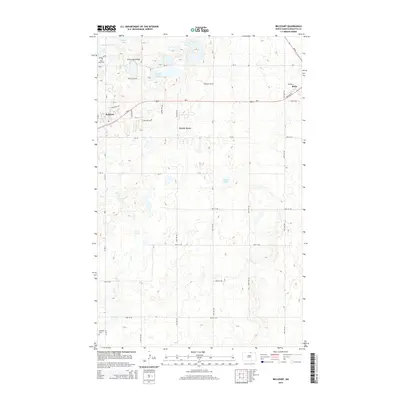
2014 Map of Belcourt
USGS Topo · Published 2014About this map
The Turtle Mountains dominate the northern landscape of this Rolette County region, where the glacial terrain creates a dense network of small water bodies like Belcourt Lake and Martin Lake. The community of Belcourt serves as a primary hub, situated near the western edge of the sheet along ND-5. Further east, the edge of Rolla appears, connected by a structured grid of local roads and Bureau of Indian Affairs routes such as Bia-5 and Bia-7. This 2014 survey reveals the detailed land-use patterns of the Turtle Mountain Plateau, where the settlement at Green Acres and several local landmarks are mapped. Genealogists can identify significant burial sites including Maryville Cem in the south and Saint Paul Cem near the northern lakes. The map provides a clear view of the area's transition from the wooded hills to the prairie roads of the northern plains.
Find a feature on this map
42 named features on this map. Tap any name to fly to it.
Don’t see what you’re looking for? This feature index may not catch every label — zoom into the map to look around manually.
Map Details
Editions of this 2014 Belcourt Map
This is the sole edition of this map. No revisions or reprints were ever made.
Other maps of this area

1936 · Lake Upsilon
USGS Topo · 1:48,000

1942 · Lake Upsilon
USGS Topo · 1:62,500

1953 · Devils Lake
USGS Topo · 1:250,000

1956 · Devils Lake
USGS Topo · 1:250,000

1968 · Lake Upsilon SE
USGS Topo · 1:24,000
1968 · Lake Upsilon
USGS Topo · 1:24,000

1968 · Belcourt
USGS Topo · 1:24,000

1969 · Saint John
USGS Topo · 1:24,000

1969 · Rolla NE
USGS Topo · 1:24,000

1970 · Rolla
USGS Topo · 1:24,000