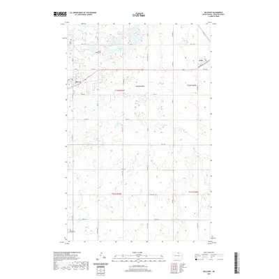
2020 Map of Belcourt
USGS Topo · Published 2020About this map
The Turtle Mountains rise across this northern North Dakota landscape, defining a region of undulating terrain and numerous prairie potholes. The settlement of Belcourt serves as a central hub, connected to the nearby community of Green Acres and the town of Rolla by an extensive network of local roads and Bureau of Indian Affairs routes like BIA Rd 4 and BIA Rd 7. The hydrology is characterized by scattered water bodies such as Martin Lake, Lucies Lake, and the winding path of Ox Cr. Genealogists and local historians will find significant landmarks including Saint Paul Cem in the northwest and Saint Marys Maryville Cem to the south. The presence of Houle School Rd and Munro Dr points to the long-standing residential and educational infrastructure that has supported these rural communities throughout the twentieth century.
Find a feature on this map
38 named features on this map. Tap any name to fly to it.
Don’t see what you’re looking for? This feature index may not catch every label — zoom into the map to look around manually.
Map Details
Editions of this 2020 Belcourt Map
This is the sole edition of this map. No revisions or reprints were ever made.
Other maps of this area

1936 · Lake Upsilon
USGS Topo · 1:48,000

1942 · Lake Upsilon
USGS Topo · 1:62,500

1953 · Devils Lake
USGS Topo · 1:250,000

1956 · Devils Lake
USGS Topo · 1:250,000

1968 · Lake Upsilon SE
USGS Topo · 1:24,000
1968 · Lake Upsilon
USGS Topo · 1:24,000

1968 · Belcourt
USGS Topo · 1:24,000

1969 · Saint John
USGS Topo · 1:24,000

1969 · Rolla NE
USGS Topo · 1:24,000

1970 · Rolla
USGS Topo · 1:24,000