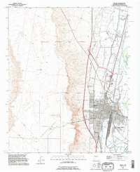
1991 Map of Belen
USGS Topo · Published 1996About this map
The Rio Grande valley in Valencia County defines this landscape, where a sophisticated network of irrigation and drainage infrastructure supports the valley's long-standing agricultural tradition. Land tenure here is deeply rooted in Spanish colonial history, evidenced by the prominent boundaries of the Nicolas Duran de Chavez Grant, the Belen Grant, and the Tome Grant. These legacy divisions transition into the mid-century development of Belen, which serves as a regional hub for transportation and commerce. A complex system of water management, including the New Belen High Line Canal and numerous ditches like the Old Belen Ditch, weaves through the valley floor to the east. Local family history is centered around settlements such as Los Chavez and Los Trujillos, and significant local sites like Our Lady of Belen Cem and Terrace Grove Cem.
Find a feature on this map
34 named features on this map. Tap any name to fly to it.
Don’t see what you’re looking for? This feature index may not catch every label — zoom into the map to look around manually.
Map Details
Editions of this 1991 Belen Map
This is the sole edition of this map. No revisions or reprints were ever made.
Other maps of this area

1952 · Dalies
USGS Topo · 1:24,000

1952 · Belen SW
USGS Topo · 1:24,000

1952 · Belen
USGS Topo · 1:24,000

1952 · Turn
USGS Topo · 1:24,000

1952 · Veguita
USGS Topo · 1:24,000

1952 · Belen NW
USGS Topo · 1:24,000

1952 · Rio Puerco
USGS Topo · 1:24,000

1952 · Tome
USGS Topo · 1:24,000

1952 · Los Lunas
USGS Topo · 1:24,000

1954 · Socorro
USGS Topo · 1:250,000