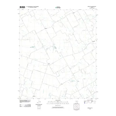
2010 Map of Belfalls
USGS Topo · Published 2010About this map
Belfalls and Blevins anchor a rural landscape dominated by a network of farm-to-market roads and seasonal watercourses in this 2010 survey of Falls County. The geography is defined by the branching tributaries of Big Elm Creek and Pond Creek, which cut through a grid of agricultural property lines and ranch roads. Small, established communities like Durango and Cego represent the persistence of small-town Texas settlement patterns into the 21st century. Local history is preserved in sites such as Theo Cemetery and Jena Cemetery, while several small-scale reservoirs, including Zaleski-Lake and Steakley Dam, reflect the management of water resources in the Blackland Prairie region. The map provides a clear look at the transition from historic settlements to contemporary land use, including naming routes like Arthur Cemetery Rd and Curtis Williams Rd.
Find a feature on this map
64 named features on this map. Tap any name to fly to it.
Don’t see what you’re looking for? This feature index may not catch every label — zoom into the map to look around manually.
Map Details
Editions of this 2010 Belfalls Map
This is the sole edition of this map. No revisions or reprints were ever made.
Other maps of this area

1892 · Temple
USGS Topo · 1:125,000

1931 · Mc Gregor
USGS Topo · 1:62,500

1931 · Belton
USGS Topo · 1:62,500

1954 · Waco
USGS Topo · 1:250,000

1955 · Waco
USGS Topo · 1:250,000

1957 · Bruceville
USGS Topo · 1:24,000

1957 · Chilton
USGS Topo · 1:24,000
1963 · Westphalia
USGS Topo · 1:24,000
1963 · Seaton
USGS Topo · 1:24,000
1963 · Lott
USGS Topo · 1:24,000