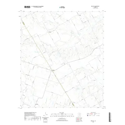
2019 Map of Belfalls
USGS Topo · Published 2019About this map
The Falls Co and Bell Co border divides this agricultural corridor of Central Texas, where scattered settlements and family cemeteries define the rural landscape. Small hubs like Blevins and Belfalls anchor the local road network, connected by routes such as FM 935 and FM 438. The terrain is shaped by several drainages, notably Hoolia Cr and Indian Grave Cr to the north, and Pond Cr and Big Elm Cr to the south. Water management for local farming and ranching is evident at Steakley Dam, which creates a significant reservoir on a tributary of Pond Cr. Local history is preserved at the Jena Cem and Theo Cem, which remain as distinct markers of early settlement patterns in this prairie region. To the southwest, the edge of Oenaville appears along Pecan Cr, illustrating the quiet continuity of these rural Texas communities.
Find a feature on this map
66 named features on this map. Tap any name to fly to it.
Don’t see what you’re looking for? This feature index may not catch every label — zoom into the map to look around manually.
Map Details
Editions of this 2019 Belfalls Map
This is the sole edition of this map. No revisions or reprints were ever made.
Other maps of this area

1892 · Temple
USGS Topo · 1:125,000

1931 · Mc Gregor
USGS Topo · 1:62,500

1931 · Belton
USGS Topo · 1:62,500

1954 · Waco
USGS Topo · 1:250,000

1955 · Waco
USGS Topo · 1:250,000

1957 · Bruceville
USGS Topo · 1:24,000

1957 · Chilton
USGS Topo · 1:24,000
1963 · Westphalia
USGS Topo · 1:24,000
1963 · Seaton
USGS Topo · 1:24,000
1963 · Lott
USGS Topo · 1:24,000