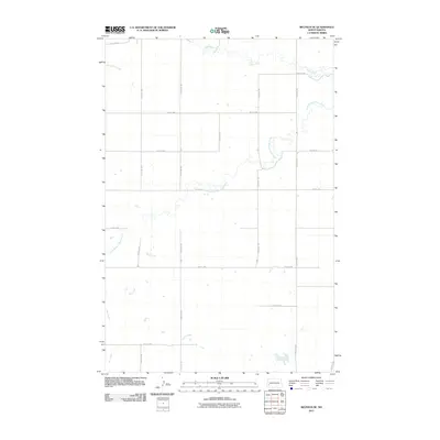
2011 Map of Belfield SE
USGS Topo · Published 2011About this map
The Heart River and its meandering tributaries dominate this Stark County landscape as it appeared in 2011. The drainage patterns of the South Branch Heart River, Norwegian Creek, and Bull Creek trace a complex hydraulic network through the western North Dakota prairie. The map reveals a strictly regulated section-line road system, where corridors such as 125th Ave SW and 40th St SW form a geometric grid typical of the Great Plains' rural infrastructure. This intersection of natural riparian wandering and rigid human engineering highlights the transition between the rolling river breaks and the high plateau ranching country during the early 21st century.
Find a feature on this map
19 named features on this map. Tap any name to fly to it.
Don’t see what you’re looking for? This feature index may not catch every label — zoom into the map to look around manually.
Map Details
Editions of this 2011 Belfield SE Map
This is the sole edition of this map. No revisions or reprints were ever made.
Other maps of this area

1953 · Dickinson
USGS Topo · 1:250,000

1957 · Dickinson
USGS Topo · 1:250,000

1961 · Daglum
USGS Topo · 1:62,500

1962 · Belfield NE
USGS Topo · 1:24,000

1962 · Belfield SW
USGS Topo · 1:24,000

1962 · Belfield
USGS Topo · 1:24,000

1962 · Belfield SE
USGS Topo · 1:24,000

1973 · New Hradec South
USGS Topo · 1:24,000

1973 · New England NW
USGS Topo · 1:24,000
1973 · South Heart
USGS Topo · 1:24,000