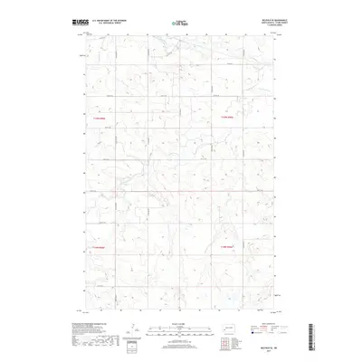
2017 Map of Belfield SE
USGS Topo · Published 2017About this map
Heart River and its tributaries carve a complex drainage pattern across this portion of Stark County, defining a landscape shaped by water and agricultural grid lines. The winding course of the S Br Heart River meanders through the central sections of the map, while Bull Cr and Norwegian Cr anchor the western drainage. This rural expanse is meticulously organized by the Public Land Survey System, as seen in the intersection of t139n r99w and surrounding townships. A consistent network of section-line roads, including W Main St and several numbered avenues like 124th Ave SW, reveals the geometric precision of the Great Plains settlement pattern. The absence of major urban centers highlights the specialized land use of the High Plains, where elevation contours indicate the subtle but significant topography of the North Dakota badlands fringe.
Find a feature on this map
22 named features on this map. Tap any name to fly to it.
Don’t see what you’re looking for? This feature index may not catch every label — zoom into the map to look around manually.
Map Details
Editions of this 2017 Belfield SE Map
This is the sole edition of this map. No revisions or reprints were ever made.
Other maps of this area

1953 · Dickinson
USGS Topo · 1:250,000

1957 · Dickinson
USGS Topo · 1:250,000

1961 · Daglum
USGS Topo · 1:62,500

1962 · Belfield NE
USGS Topo · 1:24,000

1962 · Belfield SW
USGS Topo · 1:24,000

1962 · Belfield
USGS Topo · 1:24,000

1962 · Belfield SE
USGS Topo · 1:24,000

1973 · New Hradec South
USGS Topo · 1:24,000

1973 · New England NW
USGS Topo · 1:24,000
1973 · South Heart
USGS Topo · 1:24,000