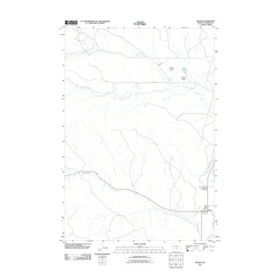
2011 Map of Belfry
USGS Topo · Published 2011About this map
Belfry serves as the primary hub of this Carbon County landscape, situated where Bear Creek meets the broader valley of the Clarks Fork Yellowstone River. The map reveals a sophisticated system of water management essential to the high plains, featuring the Shupak Ditch, Higham Ditch, and Yoast Ditch, alongside several water control structures including Shupak Number 1 Dam and Shupak Number 2 Dam. These irrigation networks demonstrate how the land was adapted for agriculture between the drainage of North Fork Dry Creek and South Fork Dry Creek. Within the small settlement of Belfry, researchers can find the Belfry Post Office and Belfry Rural Fire Dist 9, marking the community's civic center. The surrounding terrain is defined by dramatic geography like Larkin Coulee, while transportation is anchored by the Clarks Fork of the Yellowstone River Bridge, which provides a critical connection across the waterway.
Find a feature on this map
19 named features on this map. Tap any name to fly to it.
Don’t see what you’re looking for? This feature index may not catch every label — zoom into the map to look around manually.
Map Details
Editions of this 2011 Belfry Map
This is the sole edition of this map. No revisions or reprints were ever made.
Other maps of this area

1932 · Red Lodge No 1
USGS Topo · 1:48,000

1944 · Red Lodge
USGS Topo · 1:62,500

1954 · Billings
USGS Topo · 1:250,000

1956 · Bridger
USGS Topo · 1:24,000

1956 · Roberts
USGS Topo · 1:24,000

1956 · The Big Slide
USGS Topo · 1:24,000

1957 · Billings
USGS Topo · 1:250,000

1958 · Billings
USGS Topo · 1:250,000
1969 · Tolman Flat
USGS Topo · 1:24,000
1969 · Hollenbeck Draw
USGS Topo · 1:24,000