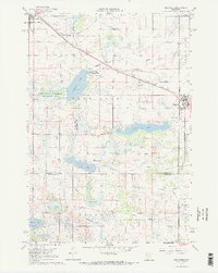
1967 Map of Belgrade
USGS Topo · Published 1968About this map
The Soo Line railroad cuts diagonally across this prairie landscape in the late 1960s, connecting the agrarian hubs of Brooten and Belgrade. This survey captures a region defined by its glacial lakes and wetlands, including the expansive Tamarack State Wildlife Management Area and the waters of Crow Lake. The rural character is punctuated by numerous small cemeteries and country parishes such as Crow Lake Ch Cem and St Donatus Cem, which serve as vital landmarks for local family historians. Near the northern edge, the Brooten Municipal Airport sits adjacent to the town site, while the winding Crow River and Skunk River drain the surrounding fields. The map also records the boundary line between Stearns and Kandiyohi counties, showing how local governance and township grids organized the central Minnesota terrain during this era.
Find a feature on this map
26 named features on this map. Tap any name to fly to it.
Don’t see what you’re looking for? This feature index may not catch every label — zoom into the map to look around manually.
Map Details
Editions of this 1967 Belgrade Map
2 editions found
Other maps of this area

1953 · Saint Cloud
USGS Topo · 1:250,000

1957 · Saint Cloud
USGS Topo · 1:250,000

1958 · Saint Cloud
USGS Topo · 1:250,000

1965 · Padua
USGS Topo · 1:24,000

1965 · Sedan
USGS Topo · 1:24,000

1965 · Elrosa
USGS Topo · 1:24,000

1967 · Mount Tom
USGS Topo · 1:24,000

1967 · Sunburg
USGS Topo · 1:24,000

1967 · Belgrade
USGS Topo · 1:24,000

1967 · Lake Johanna
USGS Topo · 1:24,000