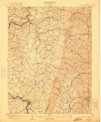
1907 Map of Belington
USGS Topo · Published 1921About this map
The Tygart River winds through the heart of this Appalachian landscape, serving as a corridor for the Baltimore and Ohio RR as it passes through Belington. This early twentieth-century survey captures a network of small, rural post office settlements and rail stations that defined the local economy before modern consolidation. Significant for family historians, the map identifies specific community hubs like Cove Run Sta Johnson PO and Montsville Sta Nicklow PO, where commerce and communication intersected at the tracks.
Find a feature on this map
85 named features on this map. Tap any name to fly to it.
Don’t see what you’re looking for? This feature index may not catch every label — zoom into the map to look around manually.
Map Details
Editions of this 1907 Belington Map
2 editions found

Other maps of this area

1886 · St. George
USGS Topo · 1:125,000

1889 · Beverly
USGS Topo · 1:125,000

1891 · St. George
USGS Topo · 1:125,000

1892 · Beverly
USGS Topo · 1:125,000

1893 · Buckhannon
USGS Topo · 1:125,000

1896 · Buckhannon
USGS Topo · 1:125,000

1897 · Buckhannon
USGS Topo · 1:125,000

1902 · Fairmont
USGS Topo · 1:62,500

1904 · Philippi
USGS Topo · 1:62,500

1907 · Thornton
USGS Topo · 1:62,500