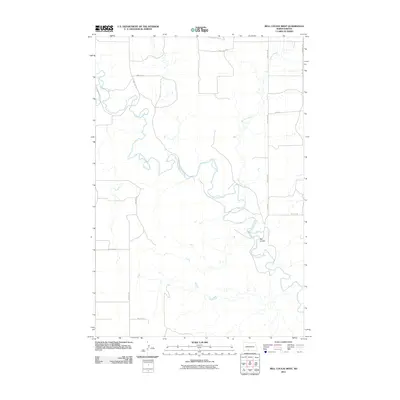
2011 Map of Bell Coulee West
USGS Topo · Published 2011About this map
The Cannonball River snakes through this Grant County landscape, defining the character of the terrain as it carves a deep valley through the North Dakota plains. Its meandering course is joined by Sixmile Creek, creating a complex drainage network that includes the distinctive Bell Coulee. This area of the Missouri Plateau reflects a modern rural infrastructure, where a grid of section-line roads like 80th Ave SW and 86th St SW provides access to the vast open tracts of the surrounding prairie. The interplay between the natural hydrologic features and the geometric road system illustrates the late-twentieth-century management of this agricultural and ranching corridor.
Find a feature on this map
13 named features on this map. Tap any name to fly to it.
Don’t see what you’re looking for? This feature index may not catch every label — zoom into the map to look around manually.
Map Details
Editions of this 2011 Bell Coulee West Map
This is the sole edition of this map. No revisions or reprints were ever made.
Other maps of this area

1954 · Bismarck
USGS Topo · 1:250,000

1958 · Bismarck
USGS Topo · 1:250,000

1971 · Lookout Butte
USGS Topo · 1:24,000

1971 · Lookout Butte SE
USGS Topo · 1:24,000

1972 · Carson SE
USGS Topo · 1:24,000

1972 · Paradise Flats
USGS Topo · 1:24,000
1972 · Pitt Creek
USGS Topo · 1:24,000

1980 · Brisbane
USGS Topo · 1:24,000

1980 · Bell Coulee West
USGS Topo · 1:24,000

1980 · Bell Coulee East
USGS Topo · 1:24,000