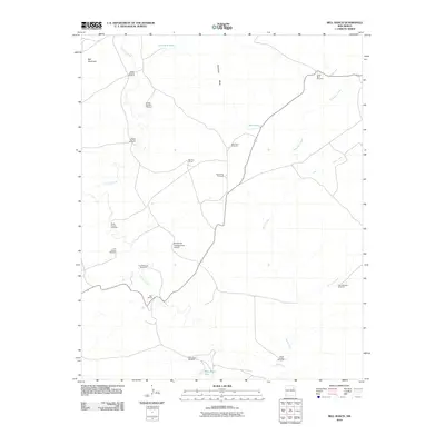
2010 Map of Bell Ranch
USGS Topo · Published 2010About this map
Bell Ranch anchors this high-desert landscape in San Miguel County, centered on a sprawling network of ranching infrastructure and water management. The area is defined by its dependency on scattered water sources and windmills, which facilitate cattle operations across the varied terrain of Huerfano Mesa and near the prominent Bell Mountain. Waterways such as La Cinta Creek and Bueyeros Creek carve through the plains, supplemented by man-made features like Red Tank and West Bronc Tank.
Find a feature on this map
24 named features on this map. Tap any name to fly to it.
Don’t see what you’re looking for? This feature index may not catch every label — zoom into the map to look around manually.
Map Details
Editions of this 2010 Bell Ranch Map
This is the sole edition of this map. No revisions or reprints were ever made.
Other maps of this area

1930 · Tucumcari
USGS Topo · 1:125,000

1954 · Santa Fe
USGS Topo · 1:250,000

1954 · Tucumcari
USGS Topo · 1:250,000

1958 · Santa Fe
USGS Topo · 1:250,000

1958 · Tucumcari
USGS Topo · 1:250,000

1968 · La Cinta Mesa
USGS Topo · 1:24,000

1968 · Carpenter Mesa NW
USGS Topo · 1:24,000

1968 · Conchas Dam
USGS Topo · 1:24,000
1969 · Campana
USGS Topo · 1:24,000

1969 · Chinaberry Canyon
USGS Topo · 1:24,000