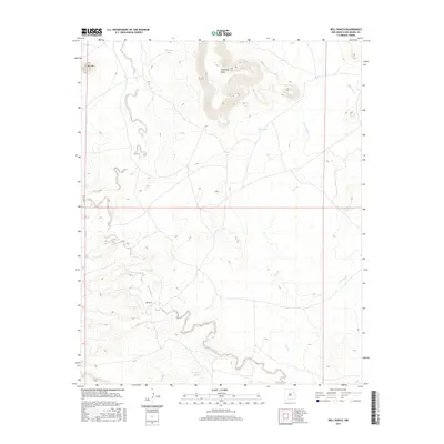
2017 Map of Bell Ranch
USGS Topo · Published 2017About this map
Bell Ranch anchors this high-plains landscape in San Miguel County, where the terrain is defined by dramatic mesas and a complex network of ephemeral drainage. To the north, the prominent silhouette of Bell Mtn and the sprawling Huerfano Mesa overlook a series of winding watercourses. The hydrology is dominated by the deeply carved path of La Cinta Creek, which meanders across the southwestern portion of the map, while Muertos Cr and Seco Cr track through the eastern flats. This map illustrates the vital role of water management in an arid ranching environment, documented through livestock-supporting features like Huerfano Tank, W Bronc Tank, and Red Tank. The sparse road network and isolated ranch headquarters reflect the vast, open-range character of this portion of northeastern New Mexico.
Find a feature on this map
12 named features on this map. Tap any name to fly to it.
Don’t see what you’re looking for? This feature index may not catch every label — zoom into the map to look around manually.
Map Details
Editions of this 2017 Bell Ranch Map
This is the sole edition of this map. No revisions or reprints were ever made.
Other maps of this area

1930 · Tucumcari
USGS Topo · 1:125,000

1954 · Santa Fe
USGS Topo · 1:250,000

1954 · Tucumcari
USGS Topo · 1:250,000

1958 · Santa Fe
USGS Topo · 1:250,000

1958 · Tucumcari
USGS Topo · 1:250,000

1968 · La Cinta Mesa
USGS Topo · 1:24,000

1968 · Carpenter Mesa NW
USGS Topo · 1:24,000

1968 · Conchas Dam
USGS Topo · 1:24,000
1969 · Campana
USGS Topo · 1:24,000

1969 · Chinaberry Canyon
USGS Topo · 1:24,000