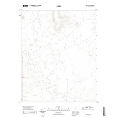
2020 Map of Bell Ranch
USGS Topo · Published 2020About this map
Bell Ranch serves as the namesake and primary human footprint in this expansive portion of San Miguel County, located along the winding course of La Cinta Creek. The landscape is dominated by high-desert landforms, most notably the prominent Huerfano Mesa in the north and the nearby Bell Mtn. The drainage network is intricately mapped, showing several ephemeral watercourses including Seco Cr, Muertos Cr, and Bueyeros Cr that carve through the arid terrain. Man-made water management features are critical to this ranching environment, with several dispersed cattle tanks such as Huerfano Tank, Red Tank, and West Bronc Tank supporting the livestock industry. The map's layout highlights the isolation of this corner of New Mexico, where land use is dictated by the availability of water and the natural barriers of the mesas.
Find a feature on this map
12 named features on this map. Tap any name to fly to it.
Don’t see what you’re looking for? This feature index may not catch every label — zoom into the map to look around manually.
Map Details
Editions of this 2020 Bell Ranch Map
This is the sole edition of this map. No revisions or reprints were ever made.
Other maps of this area

1930 · Tucumcari
USGS Topo · 1:125,000

1954 · Santa Fe
USGS Topo · 1:250,000

1954 · Tucumcari
USGS Topo · 1:250,000

1958 · Santa Fe
USGS Topo · 1:250,000

1958 · Tucumcari
USGS Topo · 1:250,000

1968 · La Cinta Mesa
USGS Topo · 1:24,000

1968 · Carpenter Mesa NW
USGS Topo · 1:24,000

1968 · Conchas Dam
USGS Topo · 1:24,000
1969 · Campana
USGS Topo · 1:24,000

1969 · Chinaberry Canyon
USGS Topo · 1:24,000