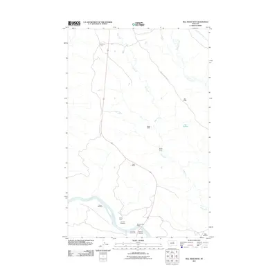
2011 Map of Bell Ridge West
USGS Topo · Published 2011About this map
Kendall Cow Camp and the winding course of the Missouri River define this stretch of Fergus County, where the high plains break into a series of named bottomlands and sharp ridges. The landscape is marked by the transition from the upland heights of Bell Ridge and Lost Ridge down into the productive alluvial soils of Knox Bottoms, Le Clair Bottoms, and McNulty Bottoms. This 2011 survey documents a remote landscape where water management and conservation are paramount, evidenced by the Bell Reservoir and the CMR Auto Nature Tour Rd providing access to the river's edge. At the southern crossing, the Missouri River Bridge serves as a critical link near the James Kipp Campground, while numerous drainages like Duval Creek and Bogg Gulch carve out the topography between the river and the northern range camps.
Find a feature on this map
18 named features on this map. Tap any name to fly to it.
Don’t see what you’re looking for? This feature index may not catch every label — zoom into the map to look around manually.
Map Details
Editions of this 2011 Bell Ridge West Map
This is the sole edition of this map. No revisions or reprints were ever made.
Other maps of this area

1943 · Landusky
USGS Topo · 1:125,000

1954 · Bell Ridge East
USGS Topo · 1:24,000

1954 · Hessler Ridge
USGS Topo · 1:24,000

1954 · Carter Coulee
USGS Topo · 1:24,000

1954 · Bell Ridge West
USGS Topo · 1:24,000

1954 · Grand Island
USGS Topo · 1:24,000

1954 · Lewistown
USGS Topo · 1:250,000

1959 · Lewistown
USGS Topo · 1:250,000

1971 · Hays SE
USGS Topo · 1:24,000
1971 · D Y Junction
USGS Topo · 1:24,000