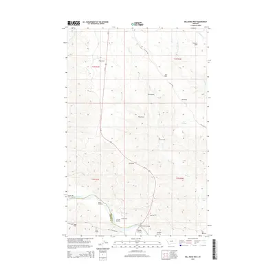
2014 Map of Bell Ridge West
USGS Topo · Published 2014About this map
The Missouri River cuts across the southwestern corner of this Montana landscape, forming the natural boundary between Fergus Co and Phillips County. This stretch of the river is defined by extensive floodplains and family-named riverbeds, including Knox Bottoms, Le Clair Bottoms, and McNulty Bottoms. The Missouri River Bridge provides a critical crossing for Us-191, which serves as the primary corridor through these breaks. To the north and east, the terrain rises into significant uplands such as Bell Ridge and Siparyann Ridge, separated by deep drainages like Bogg Gulch and Duval Gulch. An Auto Tour Rte winds through the hills, indicating the area's significance for public access and wildlife observation. The map also records water management features in this arid environment, most notably Bell Reservoir.
Find a feature on this map
28 named features on this map. Tap any name to fly to it.
Don’t see what you’re looking for? This feature index may not catch every label — zoom into the map to look around manually.
Map Details
Editions of this 2014 Bell Ridge West Map
This is the sole edition of this map. No revisions or reprints were ever made.
Other maps of this area

1943 · Landusky
USGS Topo · 1:125,000

1954 · Bell Ridge East
USGS Topo · 1:24,000

1954 · Hessler Ridge
USGS Topo · 1:24,000

1954 · Carter Coulee
USGS Topo · 1:24,000

1954 · Bell Ridge West
USGS Topo · 1:24,000

1954 · Grand Island
USGS Topo · 1:24,000

1954 · Lewistown
USGS Topo · 1:250,000

1959 · Lewistown
USGS Topo · 1:250,000

1971 · Hays SE
USGS Topo · 1:24,000
1971 · D Y Junction
USGS Topo · 1:24,000