
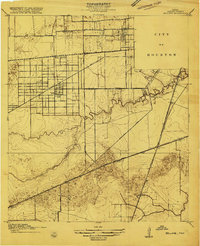
1915 Map of Bellaire
USGS Topo · Published 1915About this map
Rice Institute and the western edge of the City of Houston anchor this 1915 survey of the burgeoning Harris County prairie. The settlement of Bellaire is depicted as a distinct enclave, served by the Bellaire School and its own Bellaire Siding. The landscape is defined by the winding course of Brays Bayou and Willow Water Hole Bayou, which provide the primary drainage for the surrounding agricultural tracts and institutions.
Find a feature on this map
26 named features on this map. Tap any name to fly to it.
Don’t see what you’re looking for? This feature index may not catch every label — zoom into the map to look around manually.
Map Details
Editions of this 1915 Bellaire Map
2 editions found
Other maps of this area

1915 · Park Place
USGS Topo · 1:24,000

1915 · Houston Heights
USGS Topo · 1:24,000

1915 · Alief
USGS Topo · 1:24,000

1915 · Hillendahl
USGS Topo · 1:24,000

1916 · Settegast
USGS Topo · 1:24,000

1918 · Hillendahl
USGS Topo · 1:31,680

1920 · Mykawa
USGS Topo · 1:31,680

1920 · Almeda
USGS Topo · 1:31,680

1921 · Bellaire
USGS Topo · 1:31,680

1922 · Park Place
USGS Topo · 1:31,680