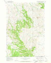
1970 Map of Belle Creek South
USGS Topo · Published 1973About this map
The Belle Creek Oil Field dominates this 1970 snapshot of the high plains along the Montana-Wyoming border. Industrial expansion is evident through a dense network of pipelines and countless Oil Wells and Drill Holes that pierce the landscape between Belle Creek and the southern Summer Camp. This resource extraction era exists alongside traditional rural infrastructure, including the Walloth Sch and an isolated Landing Strip, illustrating the region's mid-century shift toward energy production.
Find a feature on this map
24 named features on this map. Tap any name to fly to it.
Don’t see what you’re looking for? This feature index may not catch every label — zoom into the map to look around manually.
Map Details
Editions of this 1970 Belle Creek South Map
This is the sole edition of this map. No revisions or reprints were ever made.
Other maps of this area

1905 · Devils Tower
USGS Topo · 1:125,000

1954 · Ekalaka
USGS Topo · 1:250,000

1954 · Gillette
USGS Topo · 1:250,000

1955 · Gillette
USGS Topo · 1:250,000

1956 · Ekalaka
USGS Topo · 1:250,000

1957 · Cedar Ridge
USGS Topo · 1:62,500

1958 · Gillette
USGS Topo · 1:250,000

1958 · Ekalaka
USGS Topo · 1:250,000

1962 · Gillette
USGS Topo · 1:250,000

1965 · Ekalaka
USGS Topo · 1:250,000