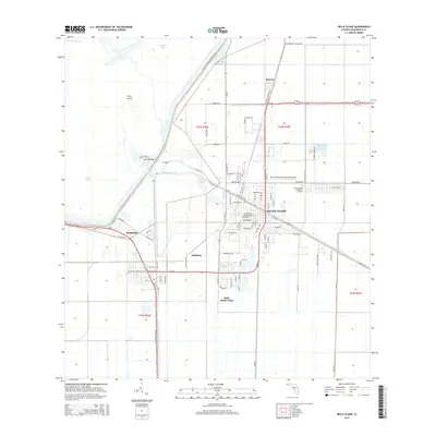
2015 Map of Belle Glade
USGS Topo · Published 2015About this map
Belle Glade and South Bay serve as the primary anchors of this inland landscape, where the agricultural geometry of Palm Beach County meets the southern rim of Lake Okeechobee. The region's history of water management is visible through the major arterial waterways of the Hillsboro Canal and the North New River Canal, which define the movement of water and commerce through the Everglades. Smaller settlements like Runyon and Dahlberg punctuate the grid, while the Belle Glade Camp and Belle Glade State Municipal Airport reflect the community's local infrastructure. Along the marshy edge of Pelican Bay, the Florida National Scenic Trail winds past Torry Island, crossing the Chosen Bridge. This layout illustrates a highly engineered environment where the road network, including Hooker Hwy and Pioneer Park Rd, follows the rigid lines of the Public Land Survey System.
Find a feature on this map
84 named features on this map. Tap any name to fly to it.
Don’t see what you’re looking for? This feature index may not catch every label — zoom into the map to look around manually.
Map Details
Editions of this 2015 Belle Glade Map
This is the sole edition of this map. No revisions or reprints were ever made.
Other maps of this area

1956 · West Palm Beach
USGS Topo · 1:250,000

1957 · West Palm Beach
USGS Topo · 1:250,000

1958 · West Palm Beach
USGS Topo · 1:250,000

1970 · Lake Harbor
USGS Topo · 1:24,000

1970 · Belle Glade
USGS Topo · 1:24,000

1970 · Lake Harbor SE
USGS Topo · 1:24,000

1970 · Okeelanta
USGS Topo · 1:24,000

1970 · Pahokee
USGS Topo · 1:24,000

1970 · Shawano
USGS Topo · 1:24,000

1970 · Bryant
USGS Topo · 1:24,000