1970 Map of Pahokee
USGS Topo · Published 1976About this map
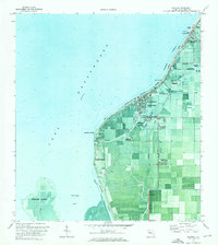
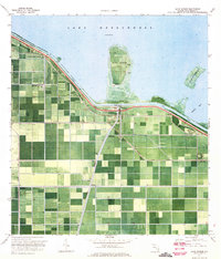
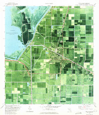
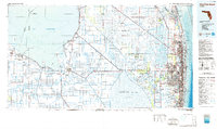
The eastern shores of Lake Okeechobee reveal a landscape defined by industrial agriculture and hydraulic engineering as it appeared in the early 1970s. This orthophotomap combines traditional topographic contours with aerial imagery, highlighting the geometric precision of the drainage systems and roads like Stuckey Rd and Bacom Point Road that segment the muck lands. The settlement of Pahokee serves as a central hub, flanked by the Pahokee State Park and the Everglades Mem Hospital.
Find a feature on this map
31 named features on this map. Tap any name to fly to it.
Don’t see what you’re looking for? This feature index may not catch every label — zoom into the map to look around manually.
Map Details
Editions of this 1970 Pahokee Map
This is the sole edition of this map. No revisions or reprints were ever made.
Other maps of this area

1956 · West Palm Beach
USGS Topo · 1:250,000

1957 · West Palm Beach
USGS Topo · 1:250,000

1958 · West Palm Beach
USGS Topo · 1:250,000
1970 · Lake Harbor
USGS Topo · 1:24,000
1970 · Belle Glade
USGS Topo · 1:24,000

1970 · Bryant
USGS Topo · 1:24,000

1970 · Sixmile Bend
USGS Topo · 1:24,000

1971 · Port Mayaca
USGS Topo · 1:24,000
1981 · West Palm Beach
USGS Topo · 1:100,000
1985 · West Palm Beach
USGS Topo · 1:100,000