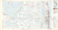
1981 Map of West Palm Beach
USGS Topo · Published 1982About this map
Lake Okeechobee dominates the western landscape of this early 1980s map, its waters edge lined by agricultural hubs like Belle Glade and Pahokee. The region's intricate water management system is on full display, with the Miami Canal, Hillsboro Canal, and West Palm Beach Canal cutting through the Everglades to drain into the Atlantic Ocean. These waterways supported the growth of specialized settlements such as Okeelanta and Canal Point while maintaining the vast Loxahatchee National Wildlife Refuge. Along the coast, the dense urban development of West Palm Beach and Lake Worth contrasts with the preserved shoreline of the John D MacArthur State Rec Area. The Seaboard Coast Line railroad provides the primary industrial spine, linking the lakeside sugarcane fields and rural towns like Clewiston to the growing metropolitan centers along the Intracoastal Waterway.
Find a feature on this map
67 named features on this map. Tap any name to fly to it.
Don’t see what you’re looking for? This feature index may not catch every label — zoom into the map to look around manually.
Map Details
Editions of this 1981 West Palm Beach Map
This is the sole edition of this map. No revisions or reprints were ever made.
Other maps of this area

1945 · Delta
USGS Topo · 1:24,000

1945 · Greenacres City
USGS Topo · 1:24,000

1945 · Lake Worth
USGS Topo · 1:24,000

1946 · Riviera Beach
USGS Topo · 1:24,000

1946 · Palm Beach Farms
USGS Topo · 1:24,000

1946 · Palm Beach
USGS Topo · 1:24,000

1947 · Delmar Farms
USGS Topo · 1:24,000

1948 · Rood
USGS Topo · 1:24,000

1948 · Gomez
USGS Topo · 1:24,000

1948 · Hobe Sound
USGS Topo · 1:24,000