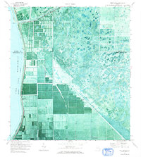
1971 Map of Port Mayaca
USGS Topo · Published 1976About this map
Port Mayaca sits at a critical junction of Florida's hydraulic engineering, where the St Lucie Canal meets the eastern shore of Lake Okeechobee. This orthophotomap, based on 1970 aerial photography, reveals a landscape defined by industrial-scale agriculture and water management. The rigid geometry of rectangular groves and fields contrasts sharply with the untamed wetlands further inland, separated by the massive Florida East Coast Dyke and the Okeechobee Waterway.
Find a feature on this map
11 named features on this map. Tap any name to fly to it.
Don’t see what you’re looking for? This feature index may not catch every label — zoom into the map to look around manually.
Map Details
Editions of this 1971 Port Mayaca Map
This is the sole edition of this map. No revisions or reprints were ever made.
Other maps of this area

1953 · Okeechobee 4 SW
USGS Topo · 1:24,000

1953 · Okeechobee 4 SE
USGS Topo · 1:24,000

1953 · Indian Town
USGS Topo · 1:24,000

1956 · West Palm Beach
USGS Topo · 1:250,000

1956 · Fort Pierce
USGS Topo · 1:250,000

1957 · West Palm Beach
USGS Topo · 1:250,000

1958 · Fort Pierce
USGS Topo · 1:250,000

1958 · West Palm Beach
USGS Topo · 1:250,000

1959 · Fort Pierce
USGS Topo · 1:250,000

1970 · West Palm Beach 2 SW
USGS Topo · 1:24,000