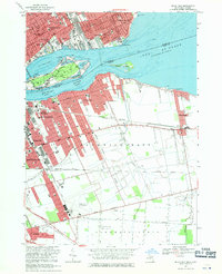
1968 Map of Belle Isle
USGS Topo · Published 1971About this map
Belle Isle Park and the Detroit River dominate this 1968 landscape, marking the international boundary between Michigan and Ontario. On the American side, the dense residential and educational grid of Detroit and Grosse Pointe Park is punctuated by neighborhood landmarks like Southeastern High Sch and Scripps Sch. The island itself serves as a recreational anchor, featuring the Detroit Boat Club, the Detroit Yacht Club, and Lake Muskoday.
Find a feature on this map
64 named features on this map. Tap any name to fly to it.
Don’t see what you’re looking for? This feature index may not catch every label — zoom into the map to look around manually.
Map Details
Editions of this 1968 Belle Isle Map
Other maps of this area

1905 · Detroit
USGS Topo · 1:62,500

1905 · Grosse Pointe
USGS Topo · 1:62,500

1906 · Wyandotte
USGS Topo · 1:62,500

1912 · Wyandotte
USGS Topo · 1:62,500

1918 · Detroit
USGS Topo · 1:62,500

1918 · Grosse Pointe
USGS Topo · 1:62,500

1924 · Detroit
USGS Topo · 1:62,500

1929 · Wyandotte
USGS Topo · 1:62,500

1934 · Detroit
USGS Topo · 1:62,500
1936 · Highland Park
USGS Topo · 1:31,680