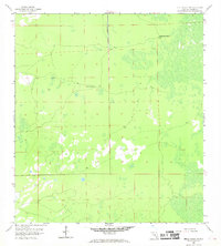
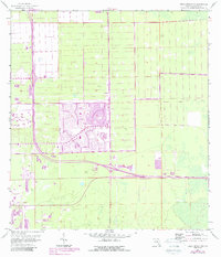
1958 Map of Belle Meade NW
USGS Topo · Published 1969About this map
The vast, wet landscape of Collier County in the late 1950s is defined by its seasonal wetlands and isolated outposts. Remote sites like Kingsville Camp and Panther Camp provide rare points of human activity amidst the extensive marsh and cypress strands of the interior. A central corridor marked as Under Construction bisects the terrain, signaling the early efforts to provide roadway access through this portion of the Everglades. The map captures a moment of transition where large-scale land management and drainage efforts were beginning to alter the natural drainage patterns of southern Florida, yet the region remained largely undeveloped and defined by its natural hydrology.
Find a feature on this map
6 named features on this map. Tap any name to fly to it.
Don’t see what you’re looking for? This feature index may not catch every label — zoom into the map to look around manually.
Map Details
Editions of this 1958 Belle Meade NW Map
6 editions found
Other maps of this area

1956 · West Palm Beach
USGS Topo · 1:250,000

1957 · West Palm Beach
USGS Topo · 1:250,000

1958 · West Palm Beach
USGS Topo · 1:250,000

1958 · Corkscrew SE
USGS Topo · 1:24,000

1958 · Bonita Springs
USGS Topo · 1:24,000

1958 · Belle Meade
USGS Topo · 1:24,000

1958 · Naples South
USGS Topo · 1:24,000

1958 · Belle Meade NE
USGS Topo · 1:24,000

1958 · Belle Meade NW
USGS Topo · 1:24,000

1958 · Corkscrew SW
USGS Topo · 1:24,000