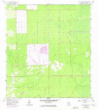
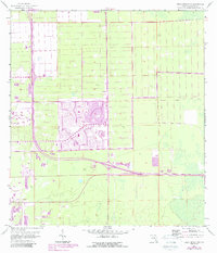
1958 Map of Belle Meade NW
USGS Topo · Published 1974About this map
Golden Gate stands as a significant marker of suburban development in the Florida Everglades during this mid-century period. Originally mapped in 1958 and updated with 1973 photovariations, the landscape reveals a transition from uninhabited wetlands to a structured grid of residential plats and leisure space, including a Golf Course and a Trailer Park. The expansion of infrastructure is anchored by the Everglades Parkway, also known as Alligator Alley, which bisects the southern portion of the quadrangle.
Find a feature on this map
12 named features on this map. Tap any name to fly to it.
Don’t see what you’re looking for? This feature index may not catch every label — zoom into the map to look around manually.
Map Details
Editions of this 1958 Belle Meade NW Map
6 editions found
Other maps of this area

1956 · West Palm Beach
USGS Topo · 1:250,000

1957 · West Palm Beach
USGS Topo · 1:250,000

1958 · West Palm Beach
USGS Topo · 1:250,000

1958 · Corkscrew SE
USGS Topo · 1:24,000

1958 · Bonita Springs
USGS Topo · 1:24,000

1958 · Belle Meade
USGS Topo · 1:24,000

1958 · Naples South
USGS Topo · 1:24,000

1958 · Belle Meade NE
USGS Topo · 1:24,000

1958 · Belle Meade NW
USGS Topo · 1:24,000

1958 · Corkscrew SW
USGS Topo · 1:24,000