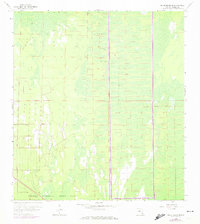
1958 Map of Belle Meade SE
USGS Topo · Published 1974About this map
Collier Seminole State Park anchors the southern portion of this landscape, where the southern Florida cypress swamps and tidal marshes dominate the terrain. The 1958 survey, updated with 1973 revisions, reveals an environment defined by its hydrology and the remains of early industrial access. The most prominent human-made feature is the Old Railroad Grade, which cuts across the marshy interior, signifying a period when timber or other resources were extracted from this wet wilderness. The map's grid-like sections and numerous depressions highlight the challenging nature of the swampy ground as it transitions toward the coast. This record of the mid-20th-century landscape provides a look at the region before modern development patterns fully took hold, preserving the location of tracks and trails used by early explorers and laborers.
Find a feature on this map
4 named features on this map. Tap any name to fly to it.
Don’t see what you’re looking for? This feature index may not catch every label — zoom into the map to look around manually.
Map Details
Editions of this 1958 Belle Meade SE Map
3 editions found
Other maps of this area

1956 · Miami
USGS Topo · 1:250,000

1956 · West Palm Beach
USGS Topo · 1:250,000

1957 · West Palm Beach
USGS Topo · 1:250,000

1958 · West Palm Beach
USGS Topo · 1:250,000

1958 · Miami
USGS Topo · 1:250,000

1958 · Belle Meade
USGS Topo · 1:24,000

1958 · Catherine Island
USGS Topo · 1:24,000

1958 · Belle Meade NE
USGS Topo · 1:24,000

1958 · Belle Meade NW
USGS Topo · 1:24,000

1958 · Belle Meade SE
USGS Topo · 1:24,000