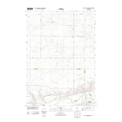
2013 Map of Belle Plaine North
USGS Topo · Published 2013About this map
The Minnesota River snakes through the southern edge of this landscape, marking a complex intersection of county lines between Scott, Sibley, and Carver counties. The northern portion of Belle Plaine sits along the river's bend, where local streets like W Court St and E Court St meet the corridor of MN-25. The terrain to the north is defined by glacial depressions and water bodies, including Maria Lake and Hoeffken Lake, alongside agricultural drainage infrastructure like Judicial Ditch Number Twentytwo. Rural life is anchored by the small settlement of Gotha and several faith-based sites, such as the Zion Lutheran Church Cem and the W Union Lutheran Church Cemetary. Notable for its many small waterways like Bevens Cr and Silver Cr, this map captures the transition from the river valley to the upland prairies of the Minnesota countryside.
Find a feature on this map
58 named features on this map. Tap any name to fly to it.
Don’t see what you’re looking for? This feature index may not catch every label — zoom into the map to look around manually.
Map Details
Editions of this 2013 Belle Plaine North Map
This is the sole edition of this map. No revisions or reprints were ever made.
Other maps of this area

1905 · Minnetonka
USGS Topo · 1:62,500

1907 · Minnetonka
USGS Topo · 1:62,500

1953 · Saint Paul
USGS Topo · 1:250,000

1957 · Belle Plaine
USGS Topo · 1:62,500

1957 · Waconia
USGS Topo · 1:62,500

1957 · New Prague
USGS Topo · 1:62,500

1958 · Victoria
USGS Topo · 1:24,000

1958 · Lake Minnetonka
USGS Topo · 1:62,500

1959 · Saint Paul
USGS Topo · 1:250,000
1981 · Norwood
USGS Topo · 1:24,000
Featured Places
- Belle Plaine, MN
- Benton Township, MN
- Valley View Terrace, Belle Plaine
- Dahlgren Township, MN
- Hancock Township, MN