
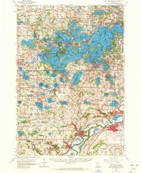
1958 Map of Lake Minnetonka
USGS Topo · Published 1959About this map
Lake Minnetonka dominates this landscape, its intricate shoreline of bays and arms such as Jennings Bay and Wayzata Bay defining the development of the region in the late 1950s. The map illustrates a mature lakeside economy where established communities like Wayzata, Excelsior, and Mound are connected by a dense network of transport, including the Great Northern and the Minneapolis and St Louis railroads. The era’s cultural and educational footprint is visible through sites like the Jesuit Seminary near St Bonifacius and the Assumption Seminary further south. Local genealogy is well-supported by numerous cemetery records, including Woodside Cem and St Marks Cem, alongside neighborhood institutions like Orono High Sch and Calvin Ch. This survey provides an essential view of the western suburbs before the post-war housing boom fully transformed the gaps between these lakeside townships.
Find a feature on this map
148 named features on this map. Tap any name to fly to it.
Don’t see what you’re looking for? This feature index may not catch every label — zoom into the map to look around manually.
Map Details
Editions of this 1958 Lake Minnetonka Map
2 editions found
Other maps of this area

1896 · Minneapolis
USGS Topo · 1:62,500

1901 · Minneapolis
USGS Topo · 1:62,500

1902 · Anoka
USGS Topo · 1:62,500

1905 · Minnetonka
USGS Topo · 1:62,500

1907 · Minnetonka
USGS Topo · 1:62,500

1909 · Rockford
USGS Topo · 1:62,500

1953 · Saint Paul
USGS Topo · 1:250,000

1953 · Stillwater
USGS Topo · 1:250,000

1954 · Hopkins
USGS Topo · 1:24,000

1954 · Eden Prairie
USGS Topo · 1:24,000