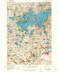
1958 Map of Lake Minnetonka
USGS Topo · Published 1972About this map
Lake Minnetonka dominates the northern landscape, its intricate shoreline defining the growth of surrounding communities like Wayzata, Excelsior, and Mound. In the mid-century era, this geography is marked by a mix of recreational shoreline and established institutional presence, such as the Jesuit Seminary near St Bonifacius and the Assumption Seminary further south. The map documents a transition from the dense lake-side developments of Minnetonka Beach and Deephaven to the agricultural reaches of Laketown and Dahlgren. Transport networks of the Milwaukee Road and Chicago and North Western connect these settlements to the industrial hubs of Chaska and Shakopee along the southern river valley. Local life is anchored by rural landmarks like Calvin Church, Lyndale School, and the St Marks Cemetery, providing essential reference points for genealogists tracing family footprints through the Hennepin, Carver, and Scott County borders.
Find a feature on this map
152 named features on this map. Tap any name to fly to it.
Don’t see what you’re looking for? This feature index may not catch every label — zoom into the map to look around manually.
Map Details
Editions of this 1958 Lake Minnetonka Map
2 editions found

Other maps of this area

1896 · Minneapolis
USGS Topo · 1:62,500

1901 · Minneapolis
USGS Topo · 1:62,500

1902 · Anoka
USGS Topo · 1:62,500

1905 · Minnetonka
USGS Topo · 1:62,500

1907 · Minnetonka
USGS Topo · 1:62,500

1909 · Rockford
USGS Topo · 1:62,500

1953 · Saint Paul
USGS Topo · 1:250,000

1953 · Stillwater
USGS Topo · 1:250,000

1954 · Hopkins
USGS Topo · 1:24,000

1954 · Eden Prairie
USGS Topo · 1:24,000