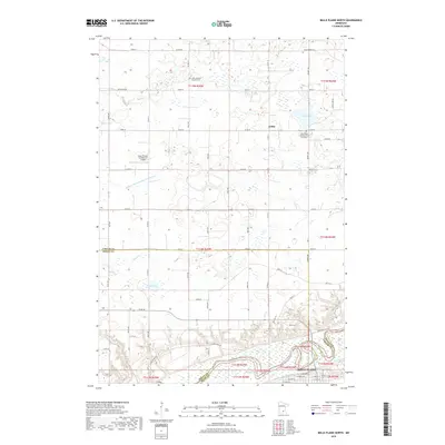
2019 Map of Belle Plaine North
USGS Topo · Published 2019About this map
The northern edge of Belle Plaine and the surrounding rural townships of Carver and Sibley counties are defined by a complex network of wetlands and drainage. The landscape is marked by substantial water bodies including Maria Lake, Kerry Lake, and Bachman Lake, while the Judicial Ditch Number Twentytwo illustrates the long-term engineering effort to manage the region's agricultural lands. The small settlement of Gotha and several family-named landmarks provide clear reference points for genealogical research, particularly the Zion Lutheran Church Cem and the West Union Lutheran Church Cemetary. Highlighting the era's local infrastructure, the Sons Private-Commercial Airport sits amidst the gridded section lines and county roads that crisscross the prairie. These patterns of roads, like Co Rd 50 and Co Rd 60, trace the development of this Minnesota river valley region into the early twenty-first century.
Find a feature on this map
50 named features on this map. Tap any name to fly to it.
Don’t see what you’re looking for? This feature index may not catch every label — zoom into the map to look around manually.
Map Details
Editions of this 2019 Belle Plaine North Map
This is the sole edition of this map. No revisions or reprints were ever made.
Other maps of this area

1905 · Minnetonka
USGS Topo · 1:62,500

1907 · Minnetonka
USGS Topo · 1:62,500

1953 · Saint Paul
USGS Topo · 1:250,000

1957 · Belle Plaine
USGS Topo · 1:62,500

1957 · Waconia
USGS Topo · 1:62,500

1957 · New Prague
USGS Topo · 1:62,500

1958 · Victoria
USGS Topo · 1:24,000

1958 · Lake Minnetonka
USGS Topo · 1:62,500

1959 · Saint Paul
USGS Topo · 1:250,000
1981 · Norwood
USGS Topo · 1:24,000
Featured Places
- Belle Plaine, MN
- Benton Township, MN
- Valley View Terrace, Belle Plaine
- Dahlgren Township, MN
- Hancock Township, MN