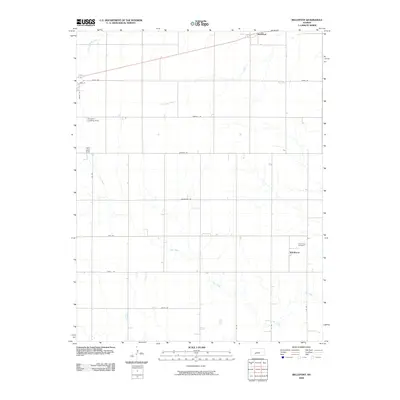
2009 Map of Bellefont
USGS Topo · Published 2009About this map
Windhorst and the nearby Holy Cross Cemetery anchor the eastern side of this Kansas prairie landscape, reflecting the rural settlement patterns of Ford County in the early 21st century. The terrain is defined by a series of subtle drainages, including White Woman Creek in the northwest, Little Coon Creek in the center, and the meandering path of Cow Creek which dominates the southern half of the quadrangle. Transport infrastructure is characterized by a precise grid of local roads like Foothill Rd and Kettle Rd, alongside more specialized landmarks such as the Knoeber Landing Strip. In the north, the small community of Bellefont sits along a primary road corridor, illustrating the continued importance of these high-plains crossroads. The layout of these agricultural roads and watercourses provides a clear view of the organized land use and hydrology typical of the region.
Find a feature on this map
20 named features on this map. Tap any name to fly to it.
Don’t see what you’re looking for? This feature index may not catch every label — zoom into the map to look around manually.
Map Details
Editions of this 2009 Bellefont Map
This is the sole edition of this map. No revisions or reprints were ever made.
Other maps of this area

1892 · Spearville
USGS Topo · 1:125,000

1894 · Spearville
USGS Topo · 1:125,000

1955 · Pratt
USGS Topo · 1:250,000

1959 · Pratt
USGS Topo · 1:250,000

1969 · Bucklin NE
USGS Topo · 1:24,000

1969 · Bucklin NW
USGS Topo · 1:24,000

1969 · Ford
USGS Topo · 1:24,000
1972 · Bellefont
USGS Topo · 1:24,000
1972 · Offerle SE
USGS Topo · 1:24,000
1972 · Spearville
USGS Topo · 1:24,000