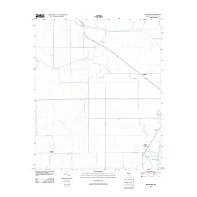
2012 Map of Bellewood
USGS Topo · Published 2012About this map
Bellewood and the nearby crossroads of Castleman define this stretch of the Mississippi Delta, where a complex network of bayous and drainage ditches supports a landscape dominated by agricultural production. The erratic path of the Yazoo River skirts the southeastern corner, connected to a legacy of water management visible in features like the Hard Cash Cutoff and Dry Bayou. The region's transport and infrastructure are represented by the Belzoni Municipal Airport and the smaller Turner Field, serving the aviation needs of the surrounding rural community. Local history is etched into the landscape through curiously named thoroughfares such as Easy Money Rd, Sloppy Deaden Rd, and Pluck Rd, which trace the boundaries of section lines and older farmsteads. These roads connect small clusters of settlement like Hard Cash to larger water bodies including Gooden Lake and Hard Cash Lake, reflecting the persistent relationship between the area's hydrology and its human development.
Find a feature on this map
53 named features on this map. Tap any name to fly to it.
Don’t see what you’re looking for? This feature index may not catch every label — zoom into the map to look around manually.
Map Details
Editions of this 2012 Bellewood Map
This is the sole edition of this map. No revisions or reprints were ever made.
Other maps of this area

1940 · Auter
USGS Topo · 1:62,500

1940 · Baird
USGS Topo · 1:62,500

1940 · Mileston
USGS Topo · 1:62,500

1953 · Greenwood
USGS Topo · 1:250,000

1954 · Mileston
USGS Topo · 1:62,500

1956 · Greenwood
USGS Topo · 1:250,000

1961 · Mossy Lake
USGS Topo · 1:62,500
1965 · Richey
USGS Topo · 1:24,000
1965 · Midnight
USGS Topo · 1:24,000

1965 · Inverness
USGS Topo · 1:24,000