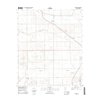
2015 Map of Bellewood
USGS Topo · Published 2015About this map
Bellewood and the smaller settlement of Castleman anchor this survey of the Mississippi Delta's agricultural heartland. The landscape is defined by an intricate network of waterways, including Beaver Dam Bayou, Little Jackson Bayou, and Tupper Bayou, which snake through the flat terrain between the Yazoo River and the eastern agricultural tracts. This 2015 data reflects a region where traditional land use and modern infrastructure meet, evidenced by the proximity of the Belzoni Municipal Airport to rural landmarks like Gooden Lake. The road system is particularly notable for its local character, featuring distinctively named routes such as Easy Money Rd, Sloppy Deaden Rd, and Poor Boy Rd, which hint at the cultural history of the farming communities and families who have long occupied these alluvial plains. The Hard Cash Cutoff on the Yazoo River further illustrates the managed hydrology critical to the local economy.
Find a feature on this map
47 named features on this map. Tap any name to fly to it.
Don’t see what you’re looking for? This feature index may not catch every label — zoom into the map to look around manually.
Map Details
Editions of this 2015 Bellewood Map
This is the sole edition of this map. No revisions or reprints were ever made.
Other maps of this area

1940 · Auter
USGS Topo · 1:62,500

1940 · Baird
USGS Topo · 1:62,500

1940 · Mileston
USGS Topo · 1:62,500

1953 · Greenwood
USGS Topo · 1:250,000

1954 · Mileston
USGS Topo · 1:62,500

1956 · Greenwood
USGS Topo · 1:250,000

1961 · Mossy Lake
USGS Topo · 1:62,500
1965 · Richey
USGS Topo · 1:24,000
1965 · Midnight
USGS Topo · 1:24,000

1965 · Inverness
USGS Topo · 1:24,000