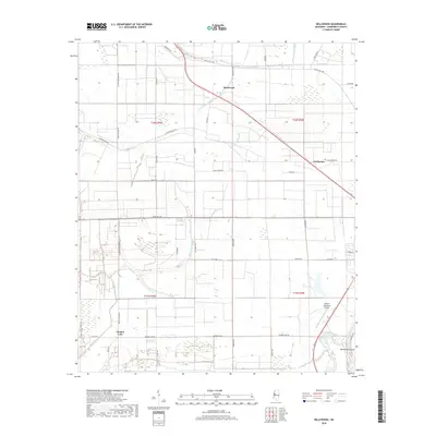
2018 Map of Bellewood
USGS Topo · Published 2018About this map
Bellewood and Castleman anchor this Mississippi Delta landscape, where the geometry of modern agriculture meets a complex network of ancient waterways. The terrain is defined by the winding course of the Yazoo River and the Hard Cash Cutoff, surrounded by oxbow features and drainage systems like Jackson Bayou and Silver Creek. A distinctive grid of rural roads—bearing local family and descriptive names such as Easy Money Rd, Po Boy Rd, and Sloppy Deadening Rd—cuts across the low-lying basin. This 2018 survey illustrates the industrial scale of Delta farming, with large rectangular fields and aquaculture ponds dominating the area around the Belzoni Municipal Airport. Toward the southern edge, Gooden Lake and Hard Cash Lake remain as visible remnants of the river's historical meanders through Humphreys County.
Find a feature on this map
47 named features on this map. Tap any name to fly to it.
Don’t see what you’re looking for? This feature index may not catch every label — zoom into the map to look around manually.
Map Details
Editions of this 2018 Bellewood Map
This is the sole edition of this map. No revisions or reprints were ever made.
Other maps of this area

1940 · Auter
USGS Topo · 1:62,500

1940 · Baird
USGS Topo · 1:62,500

1940 · Mileston
USGS Topo · 1:62,500

1953 · Greenwood
USGS Topo · 1:250,000

1954 · Mileston
USGS Topo · 1:62,500

1956 · Greenwood
USGS Topo · 1:250,000

1961 · Mossy Lake
USGS Topo · 1:62,500
1965 · Richey
USGS Topo · 1:24,000
1965 · Midnight
USGS Topo · 1:24,000

1965 · Inverness
USGS Topo · 1:24,000