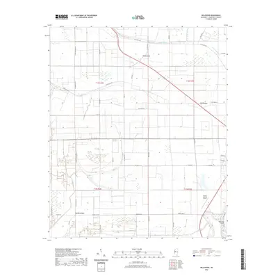
2020 Map of Bellewood
USGS Topo · Published 2020About this map
The low-lying Delta landscape of Humphreys County is defined by a dense network of watercourses, including the Yazoo River and its accompanying Hard Cash Cutoff at the southern edge. The small settlements of Bellewood and Castleman serve as agricultural hubs along the primary road corridors, while Gooden Lake sits near the winding path of Dry Bayou. The region's drainage pattern is exceptionally intricate, characterized by numerous named waterways like Jackson Bayou, Tupper Bayou, and Beaver Dam Bayou that thread between large, rectangular field plots.
Find a feature on this map
46 named features on this map. Tap any name to fly to it.
Don’t see what you’re looking for? This feature index may not catch every label — zoom into the map to look around manually.
Map Details
Editions of this 2020 Bellewood Map
This is the sole edition of this map. No revisions or reprints were ever made.
Other maps of this area

1940 · Auter
USGS Topo · 1:62,500

1940 · Baird
USGS Topo · 1:62,500

1940 · Mileston
USGS Topo · 1:62,500

1953 · Greenwood
USGS Topo · 1:250,000

1954 · Mileston
USGS Topo · 1:62,500

1956 · Greenwood
USGS Topo · 1:250,000

1961 · Mossy Lake
USGS Topo · 1:62,500
1965 · Richey
USGS Topo · 1:24,000
1965 · Midnight
USGS Topo · 1:24,000

1965 · Inverness
USGS Topo · 1:24,000