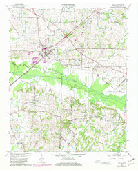
1959 Map of Bells
USGS Topo · Published 1981About this map
The town of Bells serves as the central hub of this West Tennessee landscape, situated at the junction of the Louisville and Nashville railroad and the Louisville and Nashville Memorial Highway. The surrounding countryside is defined by the winding course of the South Fork Forked Deer River, which forms a wide, vegetated corridor between Crockett, Haywood, and Madison counties. Settlement patterns follow the high ground between tributaries like Whitson Creek and Panther Creek, where small communities such as Fruitvale and Poplar Corner are anchored by rural institutions. For those researching local families, the map is a dense record of early landmarks, documenting numerous burial sites including Belleview Cem, Ramsey Cem, and Macedonia Cem. The presence of the Morris Hill Sch and Bluff Creek Sch alongside country churches like East Haywood Ch illustrates the decentralized social fabric of this agricultural region before mid-century consolidation.
Find a feature on this map
42 named features on this map. Tap any name to fly to it.
Don’t see what you’re looking for? This feature index may not catch every label — zoom into the map to look around manually.
Map Details
Editions of this 1959 Bells Map
2 editions found
Other maps of this area

1950 · Sunnyhill
USGS Topo · 1:24,000

1951 · Sunnyhill
USGS Topo · 1:24,000

1956 · Blytheville
USGS Topo · 1:250,000

1959 · Blytheville
USGS Topo · 1:250,000

1959 · Bells
USGS Topo · 1:24,000

1959 · Westover
USGS Topo · 1:24,000

1959 · Denmark
USGS Topo · 1:24,000

1959 · Adair
USGS Topo · 1:24,000

1959 · Humboldt
USGS Topo · 1:24,000

1961 · Jones
USGS Topo · 1:24,000